NOAA plans to include a lightning mapper as part of the GeoXO system. The GeoXO Lightning Mapper (LMX) will be a single-channel, near-infrared optical detector used to detect, locate, and measure the intensity, duration, and extent of lightning flashes. LMX will continue critical observations provided by the GOES-R Series Geostationary Lightning Mapper (GLM) and potentially improve its resolution. Lightning mapping from geostationary orbit improves severe storm analysis and increases lead time to detect tornado formation. The GLM also improves lightning hazard detection, hurricane intensity prediction, wildfire detection and response, precipitation estimation, and aviation hazard mitigation.
Geostationary lightning data is available where other sources are more limited, especially over oceans and in mountainous and rural areas. The data updates faster than local radar and also fills in radar coverage gaps. Lightning is an essential climate variable needed to understand and predict changes in climate. Continuing GLM observations with LMX will contribute to long-term records to track decadal changes in lightning activity.
Improvements Over Current Capabilities
Although the core capabilities would be similar for the GLM and LMX, several performance improvements are under consideration. These potential LMX improvements are motivated by current GLM users, and include finer spatial and temporal resolution, and an expanded field of view further north to include Alaska. Additional improvements would be realized through advancements in the technology being used to design and eventually build the LMX. One key difference would be the planned use of more modern CMOS (Complementary Metal-Oxide Semiconductor) imaging sensors rather than the CCD (Charge Coupled Device) sensors used on GLM.
Benefits of a Geostationary Lightning Mapper
LMX observations will continue the capabilities GLM offers by supporting persistent severe weather observations of the Western Hemisphere and providing essential forecast information for public safety and efficient economic activity across multiple sectors. During ground radar outages LMX, like GLM, will also provide crucial coverage acting as a substitute for any heavily damaged radar during disasters like hurricanes.

Severe Weather Forecasting and Warning
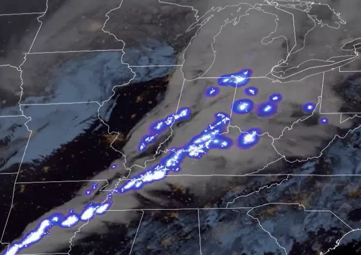
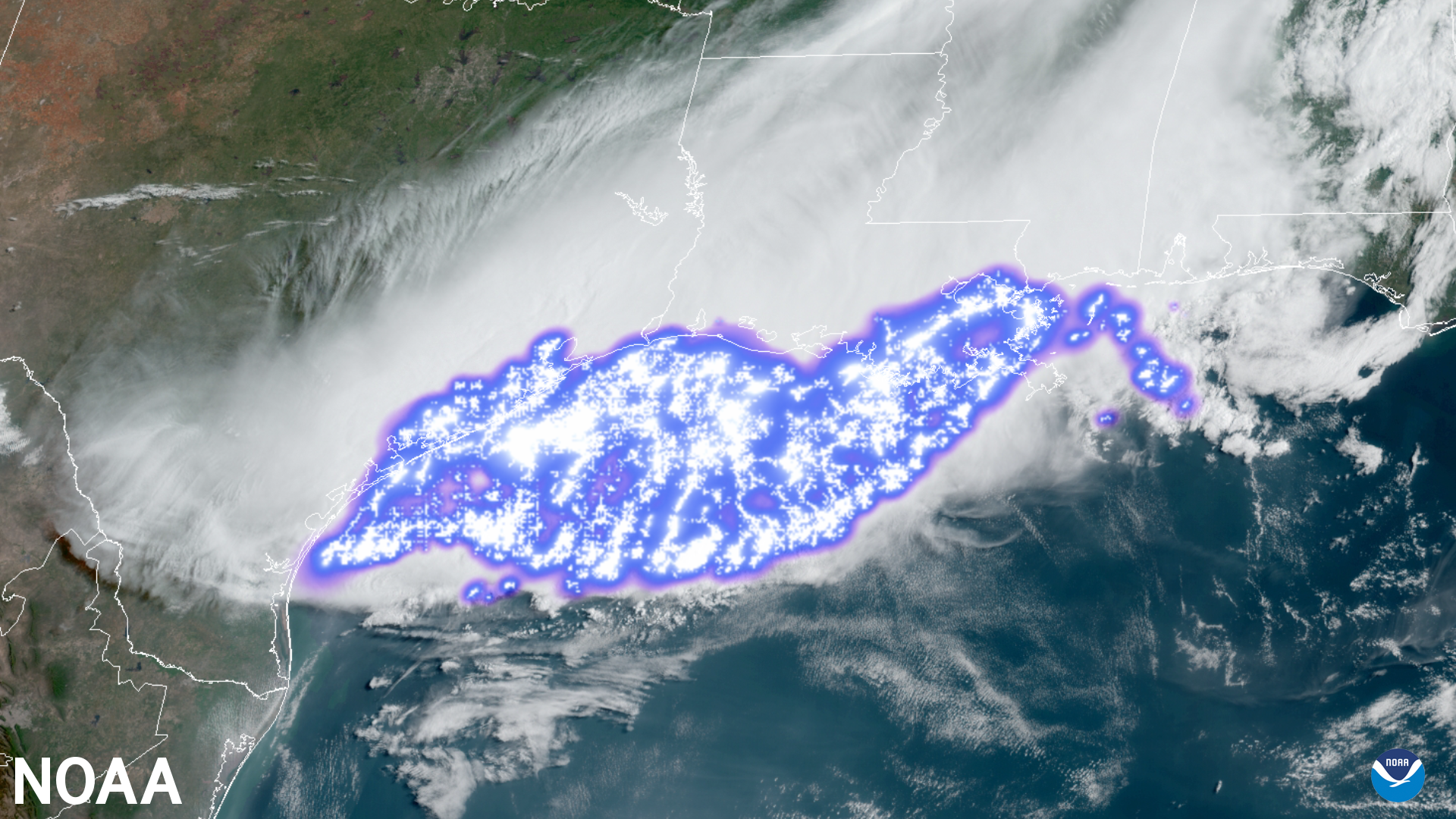
Severe storms and associated hazards have cost the United States more than 228 billion dollars in the last 20 years. Rapid increases in total lightning activity often precede severe and tornadic thunderstorms. Characterizing lightning activity in storms allows forecasters to identify intensifying storms before they produce damaging winds, hail or tornadoes. LMX data will allow forecasters to detect electrically active storms, determine the extent of the lightning threat, identify strengthening and weakening storms, monitor storm evolution, and supplement radar data where coverage is poor. Integrating GLM data into the severe weather warning process also leads to fewer false alarms, especially during radar outages and in regions with poor radar coverage.
LMX observations will also contribute to satellite precipitation estimates, benefiting flash flood forecasting in significant portions of the western continental U.S., Hawaii, and U.S. territorial islands that lack adequate radar coverage.
Hurricane Analysis and Forecasting
Forecasters will use LMX data to assess hurricanes, particularly for forecasting intensity changes, monitoring convective patterns beneath the cloud tops, and helping establish location. LMX data will help to diagnose hurricane structure and evolution and aid forecasts of intensity change including rapid intensification. Several studies noted a relationship between increased inner-core or rainband lightning activity and a change in the intensity of a hurricane. In some cases, lightning bursts preceded rapid intensification.
Wildfire Applications
Lightning-initiated wildfires account for more than half of the acreage burned in the continental United States. Many lightning-ignited fires occur in less populated areas, resulting in delayed detection and suppression.
Early Detection of Lightning-Ignited Wildfires
LMX will monitor vast areas to identify the sustained “continuing current” lightning flashes most likely to ignite fires. In continuing current strikes, rather than a lightning charge flowing in one or more separate return strokes, the charge flows continuously over a longer period through the lightning channel. This will enable emergency personnel to find small and even smoldering fires before they grow, reducing forest and property loss, lowering firefighting costs, and improving air quality.
Improving Safety and Effectiveness of Wildfire Response
Mapping potential fire starts and identifying smaller fires before they grow benefits firefighting efforts and mitigates loss of life and property. Also, intense fires can produce large plumes of heat and smoke that can generate lightning and ignite additional fires. LMX will help characterize these pyrocumulonimbus clouds that threaten firefighters by spawning erratic winds and severe weather near wildfires.
Climate Applications

Lightning data is critical to understanding and predicting changes in climate. The occurrence, distribution, and variability of lightning and thunderstorms around the globe are closely linked to Earth’s climate. A close link between lightning and convective cloud properties makes it an essential indicator of inter-annual to decadal changes in lightning activity and observing changes in climate and extreme storms.
Lightning is also a key variable for validating climate models. The NASA Goddard Institute for Space Studies (GISS) General Circulation Model (GCM) has predicted an increase in lightning activity as a result of a warmer climate, making it a good target variable for climate model validation.
Improved Air Quality Forecasts
Lightning is a major natural source of nitrogen oxides (NOx), an important greenhouse gas that affects the global climate directly. LMX will continue GLM’s capability to probe lightning/climate inter-relationships and improve air quality forecasts. In particular, LMX will be used to estimate lightning nitrogen oxides (LNOx) since trace quantities of NOx affect greenhouse gas concentrations (e.g., ozone).
Lightning Climatology
LMX will build upon two decades of GLM observations and better characterize the lightning climatology throughout the field of view. This helps establish a climatological baseline and diagnose changes.
Public Safety and Aviation Hazards
LMX will build upon GLM applications to enhance public safety across broad segments of society.
Public Safety
Lightning is a significant threat to life and property, and is particularly hazardous for those working outdoors and participating in recreational activities, and for the transportation industry. LMX data will provide awareness of local lightning conditions and promote better lightning safety decisions, leading to fewer lightning-related injuries and deaths.
In large, long-lived storm systems, lightning may travel hundreds of miles before striking the ground. LMX will show forecasters areas far from the main line of storms where the risk of lightning strikes to the ground presents a public safety hazard.
Benefits to the Aviation Industry
The air line industry will benefit from using LMX data to mitigate aviation hazards and reduce weather-related costs. LMX will support the safety and efficiency of both ramp operations and airplanes en route (and on approach). LMX can provide tremendous cost savings to the aviation industry through improved diagnosis and avoidance of thunderstorm hazards, especially over oceans. LMX will contribute to the reduction of aircraft lightning strikes by identifying electrified cloud regions that are not well-characterized by ground-based systems. LMX can also contribute to cost savings through reduced fuel burn and fewer delays and diversions.
Forensics Investigations
LMX will help authorities and insurance companies determine the existence of convection during investigations of fire cause as well as whether lightning caused a power outage or injury in remote areas. LMX data will also be used to prove the existence of convection that could be associated with high thunderstorm winds, hail, or tornadoes. LMX will provide information about the timing and intensity of lightning in the area
Environmental Hazards
LMX will also identify potentially catastrophic non-weather events such as meteors entering Earth’s atmosphere and lightning accompanying explosive volcanic eruptions.
LMX Value Assessment Report
Learn more about the benefits of geostationary lightning mapping observations in NOAA’s Technical Report: Geostationary Lightning Mapper Value Assessment
LMX Status
On April 20, 2022, NASA selected Northrop Grumman Corporation System Sector of Azusa, California, and Lockheed Martin Corporation of Littleton, Colorado, to conduct LMX Phase A Studies. Each company completed a twenty-month definition-phase study of a geostationary lightning mapper instrument. On July 18, 2023, NASA posted the GeoXO Lightning Mapper (LMX) Instrument Implementation Request for Proposals.
Related Links
- GLM fact sheet
- GLM detection methods quick guide
- GLM operational applications quick guide
- National Weather Service Lightning Safety webpage
- National Severe Storms Laboratory – Lightning Basics
- Video Weather Briefly: Lightning
The information on this page is subject to change as the GeoXO program develops.